| app | ||
| builder | ||
| cmd | ||
| color | ||
| config | ||
| docs | ||
| Godeps | ||
| maps | ||
| mml | ||
| mss | ||
| regression | ||
| render | ||
| .gitignore | ||
| crosscompile.sh | ||
| doc.go | ||
| LICENSE | ||
| Makefile | ||
| README.md | ||
| version.go | ||
Magnacarto
Magnacarto is a CartoCSS map style processor that generates Mapnik XML and MapServer map files.
It is released as open source under the Apache License 2.0.
The development of Magnacarto is sponsored by Omniscale and development will continue as resources permit. Please get in touch if you need commercial support or if you need specific features.
Features
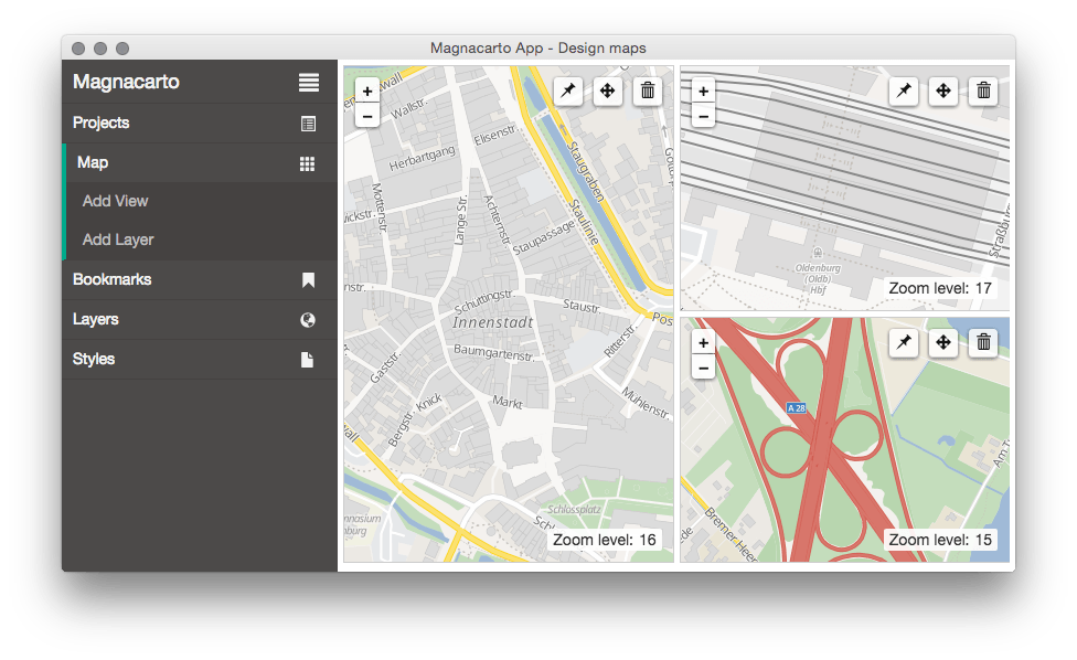
- Easy to use map viewer
- Generate styles for Mapnik 2/3 and MapServer
MapServer
Mapnik
Current status
- Supports nearly all features of CartoCSS
- Attachments
- Instances
- Classes
- Color functions
- Expressions
- etc.
- Can successfully convert complex styles (like the OSM Carto style)
Missing
- Regexp filters
- Not all CartoCSS features are supported by the MapServer builder
- Improved configuration
- ...
Installation
Binary
There are binary releases available for Windows, Linux and Mac OS X (Darwin): http://download.omniscale.de/magnacarto/rel/
Source
Dependencies
Compiling
Magnacarto contains a fixed set of the dependencies that are known to work. You need to install Magnacarto with godep to compile with this set. First create a GOPATH and install godep:
mkdir magnacarto
cd magnacarto
export GOPATH=`pwd`
go get github.com/tools/godep
Then call the following commands:
cd $GOPATH
git clone https://github.com/omniscale/magnacarto src/github.com/omniscale/magnacarto
cd src/github.com/omniscale/magnacarto
make install
Render Plugins
The web-frontend of Magnacarto can render map images with Mapserver and Mapnik.
Mapserver
The Mapserver plugin is already included in the default magnaserv installation and it requires the mapserv binary in your PATH on runtime.
Mapnik
The Mapnik plugin needs to be compiled as an additional binary (magnacarto-mapnik). You need to have Mapnik installed with all header files. Make sure mapnik-config is in your PATH. Call make install to build the plugin binary.
Usage
magnacarto
magnacarto takes a single -mml file.
magnacarto -mml project.mml > /tmp/magnacarto.xml
To build a MapServer map file:
magnacarto -builder mapserver -mml project.mml > /tmp/magnacarto.map
See magnacarto -help for more options.
magnaserv
Magnaserv is a web-frontend for Magnacasta. Make sure the ./app directory is in your working directory or next to the magnaserv executable.
To start magnaserv on port 7070:
magnaserv
Magnaserv will search for .mml files in the current working directory or in direct sub-directories.
To start magnaserv on port 8080 with the Mapserver plugin enabled:
magnaserv -builder mapserver -listen 127.0.0.1:8080
You can configure the location of stylings, shapefiles or images, and database connection parameters with a configuration file. See example-magnacarto.tml:
magnaserv -builder mapserver -config magnacarto.tml
Documentation
See docs/examples for example files and usage instructions.
Refer to the Carto project for documentation of the CartoCSS format.
- https://github.com/mapbox/carto/blob/master/docs/latest.md
- https://www.mapbox.com/tilemill/docs/crashcourse/styling/
Refer to the following CartoCSS projects for larger .mml and .mss examples.
Please note that openstreetmap-carto relies on a few advanced Mapnik features that are not supported by Mapserver. Future versions of Magnacarto might work around these limitations.
Support
Please use GitHub for questions: https://github.com/omniscale/magnacarto/issues
For commercial support contact Omniscale.
Development
The latest developer documentation can be found here: http://godoc.org/github.com/omniscale/magnacarto
The source code is available at: https://github.com/omniscale/magnacarto/
You can report any issues at: https://github.com/omniscale/magnacarto/issues
Test
Unit tests
go test -short ./...
Regression tests
There are regression tests that generate Mapnik and MapServer map files, renders images and compares them.
These tests require Image Magick (compare) and MapServer >=7 (shp2img).
go test ./...